 |  |  |
| | |
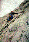
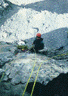
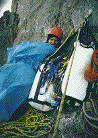
The line starts on the far right hand side of the N face in the right facing corner leading to a series of roofs. After four pitches you gain the prow of the N and W face. You take the obvious line from here with three pitches of easier free climbing (5.7) and aid (A1) until you hit a large bivi ledge. Here you now find two great pitches of climbing. The first is a thin crack with hard nailing and a dicey hook move onto a RURP (A3) to a bolt belay on the left. The next pitch is also a beauty with a four meter traverse to the right into a A1 corner to a big ledge with some good climbing (5.8). The last pitch is the only real loose one on the climb.
This was one hell of a lot of work because of the weather. We rappelled down every night but most of the belays are fixed, the odd piece of pro left so it should go in two good days. Its a great line and one I recommend. Have fun. If you need a topo call me. (Harvey Struss)
A full size version of the photos at the top of this article can be found on the Taskmaster Photo Essay page at the Rescue Dynamics website. CAUTION: 200k of images
End of the Rope, Grade 3, 100 meters
1st ascent: Rick McDonald and Brad Jones, December 22, 1996
Hidden Deception, Grade 3, 40 meters
1st Ascent. Rick McDonald & Brad Jones. January 11, 1997.
Around the corner, Grade 3, 70 meters
1st Ascent. Rick McDonald and Brad Jones.
Kevin Christakos, Tom Coe, Harvey Struss
This is a highly recommended route, could very well be one of the best rock routes in the Jasper area.
Approach to Camp        5 hours
Camp to Base of Route   2 hours
Climb                  10 hours
Descent to Camp         4 hours
Camp to Car             4 hours
Approach to Camp - Mountain Bike Fortress Lake Trail to confluence of Athabasca/Chaba Rivers. Cross rivers. 4500' traverse upward (NNW) to gain outflow of lake 6120' grd 532095. Camp in trees by creek.
Camp to Base of Route - Traverse north through trees and talus. At prominent gully angle up (W) and traverse around head of gully. Climb thick undergrowth and small cliff to reach base of main peak. Scramble up easy rock 7000' grd 533108.
Climb - 8 pitches (5.6 to 5.8) lead to a large flat area on the ridge. At the top of the next step there is a steep notch impending. Regaining the ridge, to avoid the notch, traverse west around wall to left facing corner system. Climb 2 pitches (5.9) to gain wide ledge. Follow ledge left (W) to below notch. 4th to easy 5th to notch. Regain ridge on east side. Three pitches up ridge crest leads to easy ground. Scramble last 500' or so to summit.
Descent - Descend westward to col, traverse upward and around north side of sub peak to next col to the SW of main summit grd 523106. Descend gully back to lake. (Kevin Christakos)
Map Sheet 83 C/5 Fortress Lake
April 23, 1995, Harvey Struss and Rob Youngberg
This ice climb is located above the SW corner of Talbot Lake (Jasper end). The ice is visible from the road. Make sure you identify which drainage the route is in before heading off. It is a 45 minute approach through large clearings and then fairly open bush until reaching the creek bed draining the climb.
The route begins with short steps that lead to a full 50m pitch. Above, there is a l0m, 85 degree step that leads to other shorter steps. Walk off to the left following a faint sheep trail, or rappel using trees. This is a beautiful climb to do in the spring, watch wind surfers on Talbot Lake while climbing plastic ice. (Harvey Struss)
by Greg Horne
In March 1989 Richard Parsloe and I had just returned to the parking lot after a failed winter attempt to climb Mt. Robson. We spied two guys getting their gear ready to go climbing. Two parties back to back attempting Robson in winter? Wow, things are getting busy here! Not likely though, just a coincidence. Their gear and clothes caught our attention, were we time warping? It looked styled from about twenty years earlier. Better check them out and see what's going on.
It turned out one of the fellows, Les Wilson, had first attempted Robson in winter with Leif-Norman Patterson in 1963 or 1964 (see CAJ Vol. 48, page 109). Patterson was exploring an access route to The Dome from the south side. In particular he was interested in climbing a huge couloir which leads directly to The Dome. In his attempt with Les Wilson they abandoned the "Patterson Couloir" in favour of a spur ridge dropping from the south side of the Robson - Resplendent col. This spur was approached by skiing up the valley that joins the Robson River just downstream of Kinney Lake. It must have been an extremely intimidating place as huge slide paths flank this valley's sides. Climbing the spur proved straightforward, mainly trail breaking in snow and step kicking. When they reached the col, it was bitterly cold and although giving up the idea of climbing Robson, they bagged Resplendent, then skied down the Robson Glacier to Berg Lake and out.
The idea of accessing The Dome from the south side of Robson - Resplendent had intrigued me for some before my meeting with Les Wilson. This chance or fate meeting refueled my interest in the possibilities of using the this much safer spur to gain access to The Dome.
I had to wait until September 1994 to check out this route. It had been an incredibly good summer, weather wise, for Robson. Thirteen people had summited Robson in one day just before Harvey Struss and I started our exploration climb on the south side. In summer, I had no desire to head up the valley bottom Patterson and Wilson had used in winter, Devil's Club and unknown canyon's scared me away. Instead we used the steep but direct approach to the Ralph Forester Hut as our start. A rain and thunder storm, while camped at Kinney Lake, was the warning of foul happenings to come. A continuous cold shower from the dripping vegetation crowding the fall line trail to the timberline was a refreshing compliment to our predawn start.
Just above the last headwall and below the hut the Yellow Bands are reached. These bands allow an easy traverse left to the base of the Wishbone Arete. Instead, we traversed them right crossing the ridge the hut is situated on, about 300 or 400 feet below the hut. Serac debris well below the toe of the South Face hanging glacier was crossed then begin a several hour traverse of the Yellow Bands. The scree was generally soft and with an ice axe in the up hill hand and ski pole in the lower hand, travel was rapid.
When we turned the broad corner and were able to first see the Patterson Couloir, crossing it looks ominous. There was a serious bergschrund below and rocks were tumbling down the couloir. However, when we got right beside the couloir it seemed much tamer. One at a time we spotted each other across the soft snow, constantly checking above for falling bombs. Next a minor crossing of a different bergschrund was the only place we needed to rope up to reach the Robson - Resplendent col. A right diagonal traverse lead us to the spur ridge about one third the way up it from the base. Here was a good camp site with a snow bank for water supply. We pressed on up the spur. It was at first just scree, but then it degraded to gravel covered downsloping slabby steps that demanded attention to detail. The col was reached just in time to set up camp before dark. It had taken about 12 hours from Kinney Lake to the col. We had hoped to reach The Dome in one day, but not this trip. A good storm moved in and during two nights at the col it left a foot of heavy wet snow. On the second morning we pulled the pin. Retreating down those gravelly slabs, now covered with snow, was out of the question. We groped our way down into the whited out Robson Cirque, making a couple bonus detours into optional serac mazes, before continuing down the Robson Glacier and out to the parking that evening.
Robson's summit remained elusive but we confirmed there is a reasonable route to access The Dome from the Ralph Forester Hut. A better schedule would be an easy half day hike to the hut, then on day two traverse the Yellow Bands, head up the Patterson/Wilson Spur and reach The Dome.
On the Alberta - B.C. boundary, about 15 kms northwest of Yellowhead Pass, is located this prominent quartzite peak. The east ridge forms the right-hand skyline, when viewed from Highway 16 near Clairvaux Creek. An approach was made up the Miette Pack Trail until directly across from the objective, then a bushwack to a camp by a small lake at 6200 feet, 2.5 kms east of the mountain.
We followed a moraine to the base of the east ridge which was then climbed directly (3 pitches) then short roped to about 8000 feet where the ridge steepened. Six belayed pitches mixed with short roping overcame the difficulties of the ridge. The rock quality of the ridge varied from very solid to rotten friable bands, but was generally good. The belayed pitches were mostly easy lower fifth class, 5.4, with a couple 5.6 moves here and there.
On the east summit we found a small cairn. Excellent solid quartzite lead us to the main or central summit where no cairn or sign of previous ascent was found. A cairn was built and register left. A straightforward descent, on small brown scree, was made down the southeast face via a shallow diagonal gully starting between the east and main summits. We then climbed over an 8000 foot pass just south of point 8327 ft. and dropped down to camp. This was an outing of the Jasper/Hinton Section of the Alpine Club of Canada.
First ascent of East Ridge, September 23, 1994, by Harvey Struss, Brian Gibson and Greg Horne.
Ghost Falls 175 m, III, WI 4
On the southwest face of Mount Kerkeslin there is a waterfall ice climb in each of its four major drainages. Ghost Falls was the last of these four climbs to be ascended. Two unsuccessful attempts preceded the first ascent, tricky route finding up forking creek beds led to its name and reason for at least one failed attempt. The approach begins from the entrance of Mt. Kerkeslin Campground on HWY 93, south of Athabasca Falls. The top pitch of the climb can be viewed if one drives about a half kilometre south of the campground entrance.
A one hour hike up the dry creek bed led us to the huge chockstone lodged between the canyon walls. We propped up a log and front pointed up it to over come this obstacle, it can also be bypassed by delicate climbing on the left wall of the canyon. The ice climbing began with a short 10 metre pitch. A normally dry second pitch was bypassed in the forest to the left. More creek bed walking followed to the first fork, right turn and the next pitch of ice. We continued walking to the next fork and turned left which lead we to the base of the final two pitches, grade WI 4 ice.
First ascent by Ed Laporte and Greg Horne, December 27, 1989.
See the Canadian Alpine Journal 1994 for photos.
 Last updated: